To truly understand sailing weather, you first have to grasp the basics: a constant interplay between pressure, temperature, land, and sea. In a region as diverse as Europe and the Mediterranean, these fundamentals are then uniquely shaped by everything from mountain chains and sea breezes to sprawling high-pressure systems.
Pressure, temperature and gradients
- Wind is simply air moving from high to low pressure; the steeper the gradient, the stronger the wind (all else being equal).
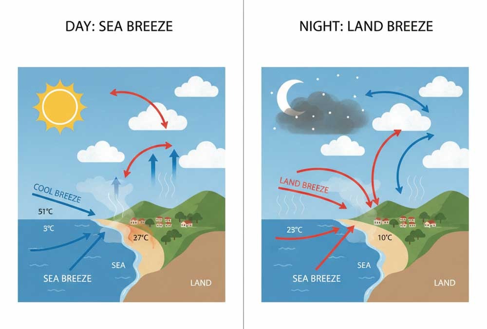
- So, over the summer period, land heats the air making it less dense thus building low pressure; conversely over the cooler sea area there is a relative higher pressure. These contrasts drive sea breezes along coasts, i.e. the term ‘sea breeze’.
- Then, at upper levels, jet streams and troughs/ridges aloft modulate surface pressure systems and can lead to shifts or wind reversals.
- The Coriolis effect (Earth’s rotation) deflects winds to the right in the Northern Hemisphere, so winds tend to flow parallel to isobars rather than directly across them.
Diurnal patterns & thermal winds
- In many Mediterranean coasts, a sea breeze / land breeze cycle develops: by late morning, land heats up, drawing air from the cooler sea; in evening, land cools, and flow may reverse.
- Also, in narrower gulfs or near mountain ranges, katabatic (downslope) winds or anabatic (upslope) breezes can channel wind into or out of valleys or straits.
Terrain & funnel effects
- Mountain ranges and valleys act as channels or barriers. For instance, the Rhône Valley funnels and accelerates the Mistral toward the Gulf of Lion.
- However, islands and peninsulas break up the wind, cast turbulence or eddies. Localised shear zones and vortex shedding are common in straits like between islands or through mountain passes.
- Sea surface temperature (SST) differences can also influence near‑surface stability, especially in transitional seasons.
Synoptic vs. local drivers
- Large pressure systems (anticyclones, depressions) set the baseline wind regime across Europe and the Med.
- On top of that, mesoscale features like coastal convergence, thunderstorms, thermal zones can cause sudden shifts, gusts or lull zones.
- In transitional seasons (spring, autumn), fronts may sweep through rapidly, creating shifting winds and unsettled seas.
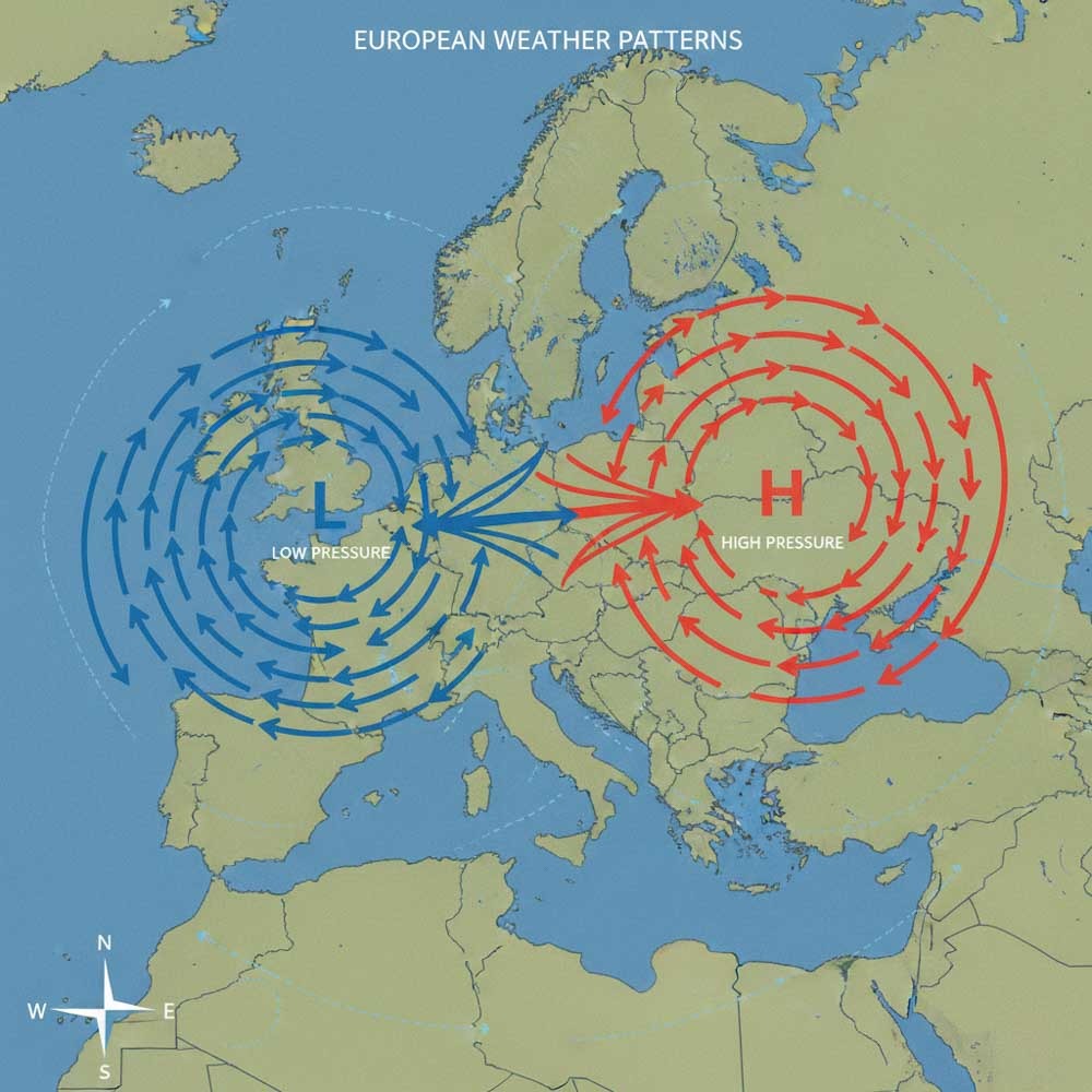
When you sail in European waters, keep your eye on both the broad synoptic map and the local terrain interactions.
Seasonal considerations
Wind regimes in Europe and the Mediterranean vary quite predictably with the seasons. Knowing when certain winds are more likely can help with route planning, safety margins, and expected workload.
Spring (April–June)
- Pressure systems are shifting; cold fronts still penetrate south. Expect variable winds, gust fronts, and changeable days.
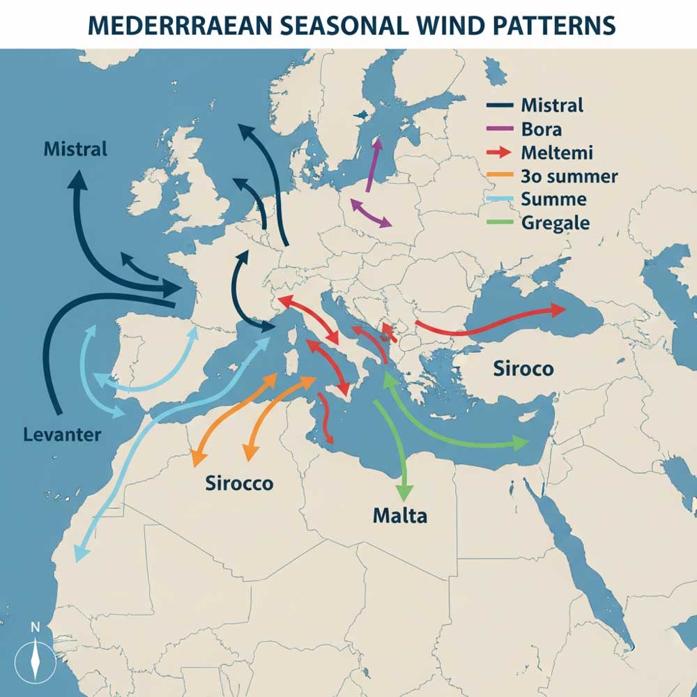
- In the western Mediterranean, the Mistral begins to appear more frequently from late spring, when a high over the Atlantic and low pressure over the Gulf of Genoa set up a strong north-westerly funnel through the Rhône.
- In the Aegean / eastern Med, meltemi (etesian) winds start to form by late May, bringing steady north or northeast winds midday, dying at night.
- Transitional storms: fronts may creep in, especially at the edges of the Med basin.
Summer (July–August)
- High pressure dominates central Mediterranean; skies are often stable, though thermal winds are active.
- Meltemi / Etesian in the Aegean / Cyclades region become a defining feature. These dry northerlies can hit 25–35 knots, often strongest in afternoon and easing overnight.
- In the Ionian Sea or western Mediterranean areas, summer winds tend to be milder, often sea breezes or occasional local gusts, unless a trough or heat low forms.
- But you need to be cautious of occasional sirocco / scirocco (southerly wind from Sahara) intrusions, which bring dust, humidity, and unsettled conditions.
Autumn (September–October)
- A return of frontal systems, more instability. Expect shifting winds, thunderstorms, and sometimes gales as strong systems dip south.
- The Mistral can reassert more strongly, especially in September, as pressure contrasts intensify.
- The meltemi generally dies out by mid‑September; residual northerlies may linger.
- In late autumn, Euroclydon or Gregale / Levanter winds may emerge as storms from the east or northeast and will affect the central Med.
Winter (November to March)
- Frontal systems sweep through more frequently; strong winds and unsettled seas are common.
- The Mistral is active in winter and spring, sometimes lasting days.
- In the Adriatic and northeastern Mediterranean, the Bora is a frequent katabatic wind blowing from the northeast, often cold and gusty.
- In western Med, expect westerlies and southerlies associated with passing low systems.
- Storms can intensify rapidly — watch for pressure steepening and wind shifts.
Tip: When planning a Mediterranean cruise, aim for the “shoulder” months (late spring, early autumn) to avoid extremes, but still enjoy wind consistency.
Reading wind patterns
This is where theory meets practice. By combining charts, indicators, and observation, you can “read” the wind before it arrives.
Synoptic chart reading
- Identify areas of high and low pressure, frontal zones, and isobar spacing. Tight isobars = stronger winds.
- Over the Mediterranean, look for pressure ridges or trough axes and how they align with coastlines or mountains.
- Pay attention to the direction the isobars are “bending” near terrain — that can indicate funnelling or deflection.
- Watch for cold fronts (sharp wind shifts, gusts) or warm fronts (gradual veering), and occlusions (variable, unstable wind zones).
Local read‑outs & cues
- Look for cloud movement at different altitudes — upper vs mid vs low clouds can show shear, flow direction aloft.
- Observe smoke, land haze, sea spray — they often reveal low-level direction changes or gust zones.
- Monitor barometric trends: a falling barometer usually signals an approaching low or front, while rising suggests high building.
- Watch wind shadows / lulls near shorelines or lee of islands — abrupt changes may signal gusty edges or eddies.
- Use wind shifts as front edges approach — a veer (clockwise) or back (anticlockwise) shift can tell you which side of a front you’re on.
Recognising key Mediterranean wind types
Here are some of the signature winds you should recognise as you sail the Med:
| Wind Name | Region / When | Direction & Character | Sailing Impacts |
| Mistral | Western Med, especially Gulf of Lion / Provence | NW / Northwesterly, cold, dry, funneled down Rhône valley | Strong, sustained, good upwind legs if aligned; can produce steep seas and require reefing. |
| Meltemi / Etesian | Aegean, eastern Med (May‑Sept) | Northerly / NE to N, steady thermal type | Favours downwind or beam reach legs, peaking in afternoon. Requires local timing. |
| Bora | Adriatic, NE Mediterranean in winter | N / NE, cold, gusty, katabatic | Often strong gusts, sudden shifts; cautious in narrow channels. |
| Sirocco / Scirocco | Central / southern Med | SE / South‑east, hot, humid, sometimes dusty | Brings unsettled weather, visibility issues, heavier seas. |
| Gregale (Gregale / Levanter / Euroclydon) | Central & eastern Med | Northeast, cyclonic impulse | Sudden northeaster, often in transitional seasons. |
| Marin | Gulf of Lion / coastal Languedoc | SE / SSE warm wind | Can enhance swell from east, may bring rain. |
When you see a synoptic chart showing a deep low east of Greece and high pressure over Europe, you might expect a Gregale or Euroclydon to push into central Med. Likewise, tight isobars across Corsica / Sardinia hint at a Mistral event.
Forecast validation & tweaking
- Always cross-check multiple models (GFS, ECMWF, ICON, etc.) — they may differ in timing or magnitude.
- Compare forecasted wind direction with observed (even at anchor) and adjust your mental model.
- “Nowcasting” — use latest satellite, radar, buoy or buoy‑based wind data to validate early forecasts and detect anomalies.
- For longer passages (multi-day), consider routing tools that incorporate performance polar data, wave models, and atmospheric consistency over time.
By combining synoptic reading, local cues, and forecast validation, you sharpen your “sixth sense” for wind.
Weather apps and tools
A modern sailor’s greatest ally is technology. But not all apps are equal. The trick is using the right tool and interpreting it appropriately.
What to look for in a sailing weather app
- Multiple meteorological model sources (ECMWF, GFS, ICON, etc.) so you can compare forecasts.
- Wind, wave, pressure contours, rain, temperature layers, and ability to overlay isobars.
- Tide & current data (especially in tricky straits).
- Alerts / thresholds for wind shifts, gusts, pressure drops.
- Good usability (map interface, time slider, clear units, local time handling).
- And for the more serious sailing, perhaps offshore
- GRIB file download / offline caching (for offshore or weak cell signal)
- Routing features that allow you to input your boat’s performance (polar data) and let the app suggest optimal legs.
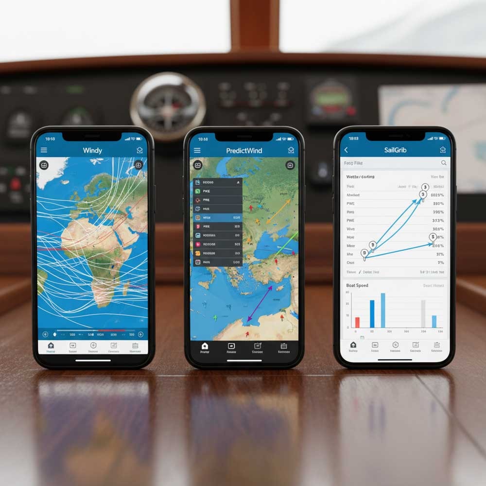
Top apps and tools
Here are some standout apps used by sailors in Europe & Med environs:
- PredictWind — robust routing, GRIB download, departure planning and custom overlays.
- Windy.com — excellent visualisation, multiple models, user overlays, intuitive interface.
- Savvy Navvy — integrates charts, routing, weather, tides in one dashboard.
- Windfinder / Windy — handy for quick lookups, popular with many sailors.
- Garmin (Navionics) Boating — charts + overlaying weather forecasts; strong in Mediterranean marina coverage.
- SailGrib / SailGrib WR — good for GRIB reading, model comparison, routing.
The best weather apps tend to charge subscription fees, however when in the Med on a cruising vacation you should get by with a good free app like Predictwind or Windy.com free accounts.
Integrating tools into your workflow
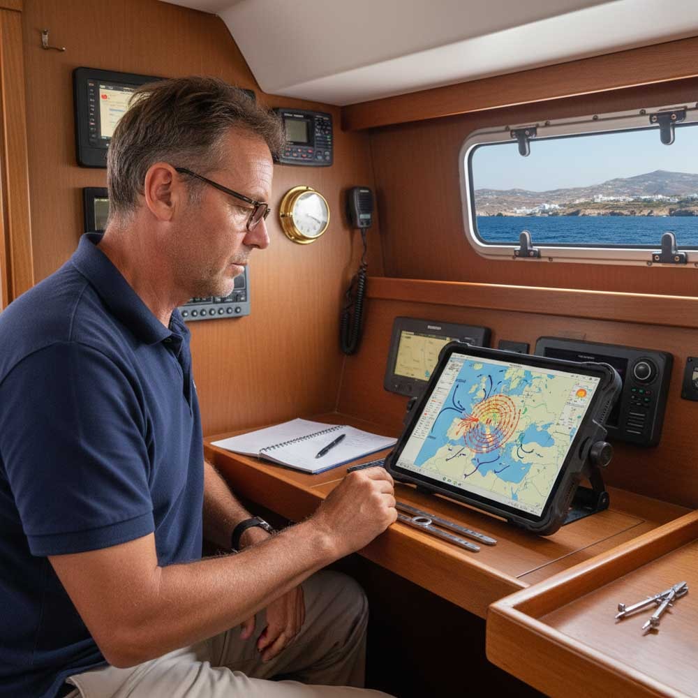
- Pre‑cruise planning — use a desktop app or web forecasts to map synoptics, route options, and wind forecasts 3–5 days ahead.
- Download GRIBs / model data in advance — where cell signal is weak or expensive, having offline data is a lifesaver.
- Onboard cross‑checking — keep a backup app or chartplotter, compare forecast and observed data, log deviations.
- Alerts & watch mode — set thresholds so you get notified if wind exceeds or shifts beyond safe limits.
- Fallback tools — paper charts, barometer, hand bearing compass, wind vane — always maintain manual skill in case electronics fail.
With the right mix of human judgement + app insights, you’ll elevate from following wind to anticipating it.
Closing
Wind reading is both art and science. In European and Mediterranean sailing waters, you must balance large‑scale synoptic forces with local quirks of terrain, sea breezes, and thermal shifts. Now, you have better models, better apps, and more data than ever—but the key remains your experience, observation, and willingness to recalibrate.
So on your next Med passage or island hop, don’t just trust the forecast—read the clouds, listen to the air, sense the day’s momentum. Over time, what seems mysterious becomes intuitive: you’ll sail not just by wind, but with it.
Read Next
- Best Sailing Navigation Apps
- ASA, NauticEd or RYA Sailing Certification
- Complete Beginners Guide to Sailing
Ready to Set Sail? Download my FREE Comprehensive Sailing Weather Guide which provides a lot more information from cloud formation to Beaufort Scale, global barometer readings and weather terms. A must have for any sailor.
Finally, check out my selection of preferred apps here and explore hand-picked sailing gear to make your journey easier. Your adventure starts now.