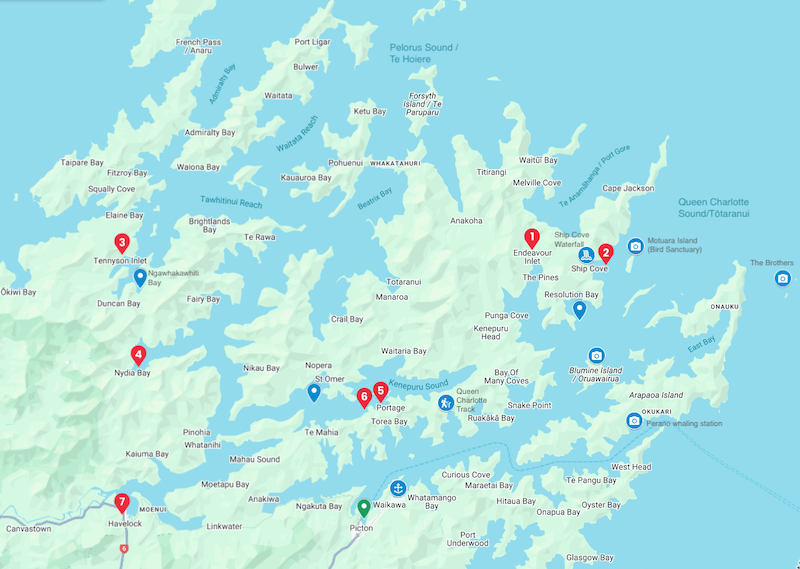
Queen Charlotte Sound/Tōtaranui & Pelorus Sound/Te Hoiere
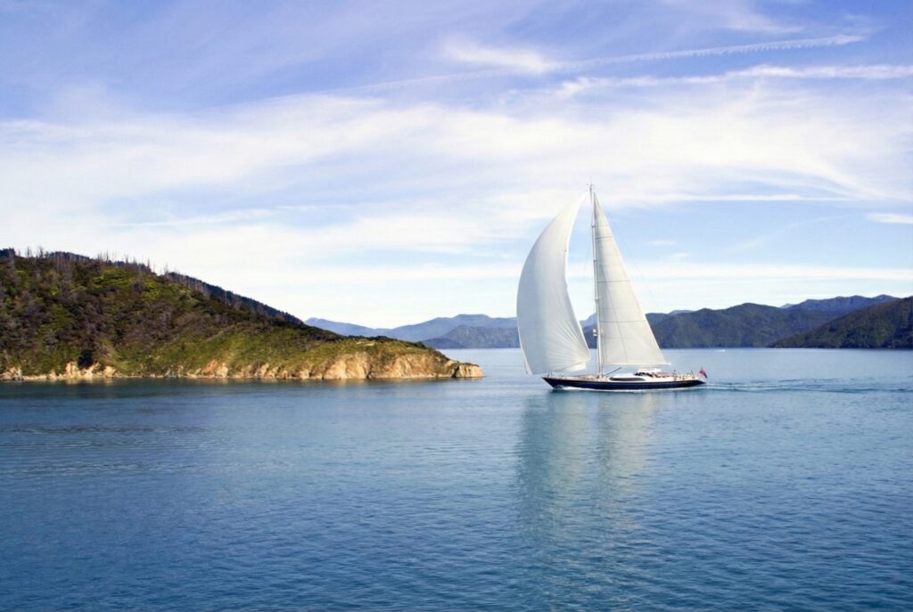
Sail from Picton to Havelock through Queen Charlotte and Pelorus Sounds, pausing at Endeavour Inlet, Ship Cove, Nydia Bay and Portage. Spot bird sanctuaries, visit historic Meretoto/Ship Cove, walk sections of the Queen Charlotte and Nydia Tracks. An unhurried Marlborough Sounds New Zealand sailing experience with room to explore.
A relaxed 7-day Marlborough Sounds New Zealand sailing route, mixing iconic anchorages, bird sanctuaries, walks, and classic pubs.
Overview
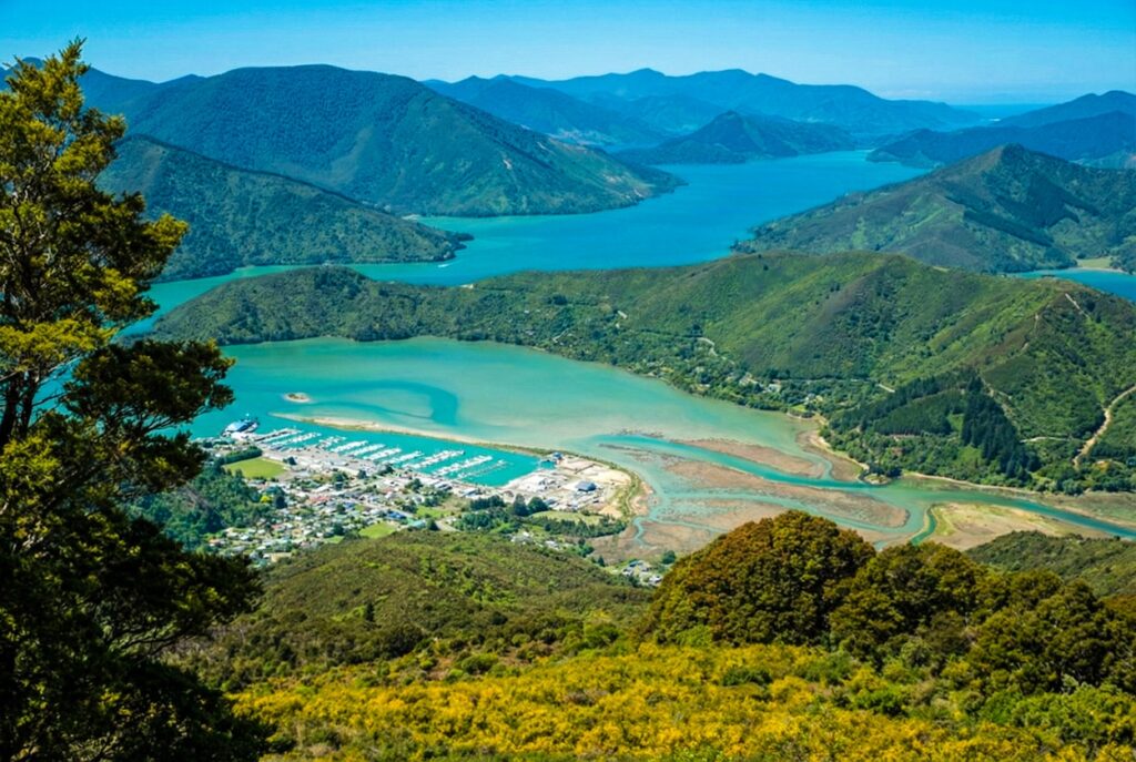
The Marlborough Sounds feel like New Zealand’s coastline gently folded in on itself. Steep, bush-covered hills plunge into calm waterways, and long drowned valleys shelter a maze of bays, coves and inlets. It’s a place made for unhurried exploring by boat, especially on a week-long Marlborough Sounds New Zealand sailing escape. Your route runs from Picton in Queen Charlotte Sound/Tōtaranui through to Havelock at the head of Pelorus Sound/Te Hoiere, threading between small lodges, wildlife islands and historic anchorages used by Captain James Cook. Picton and Havelock are both well-served marina towns, with cafés, fuel and green-lipped mussels waiting at each end of the voyage. Summers here are among the sunniest in the country, with warm days, generally settled conditions and plenty of sheltered water away from Cook Strait’s rougher moods. Even in shoulder seasons you often get clear, crisp days with good visibility, though you still respect southerly changes and early fog. It’s a friendly, welcoming piece of coast. There’s enough navigation to keep you engaged, but not so much that you spend the whole time hunched over the plotter instead of enjoying the view from the cockpit. This is a 7 day one-way itinerary that gives time to enjoy and see the sounds. However alternatives worth mentioning, should you wish to return to Picton, are: 1) with careful planning one could cut a couple of the stops out e.g. 1 night only at Endeavour Inlet/Ship Cove and one night only at Portage, thus giving time to return to Picton, 2) make it a 10 day itinerary, allowing time to return to Picton over 3 days.
Special Gems
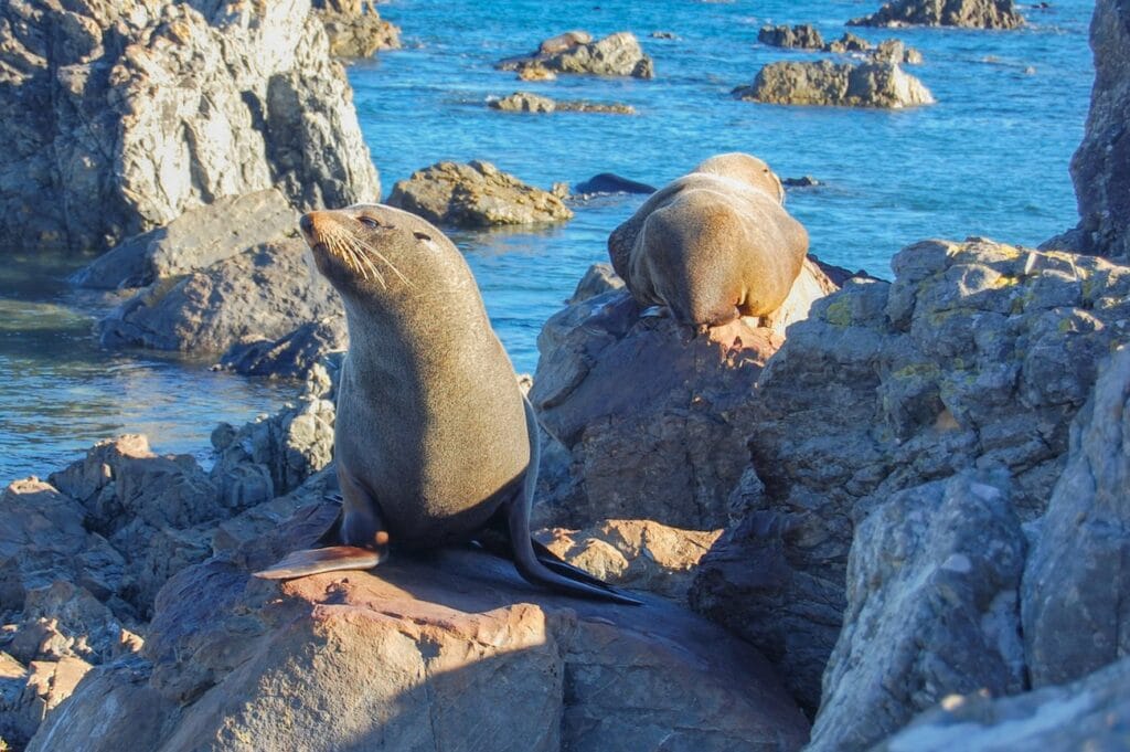
A few extras deserve attention when planning this Marlborough Sounds New Zealand sailing journey. First are the wildlife sanctuaries of Motuara Island and Blumine Island/Oruawairua. Both are predator-free conservation areas where native birds thrive; Motuara in particular is known for its dawn chorus and views from the summit lookout.
Blumine Island, you’ll have the chance to see extremely rare bird species like the Orange-fronted Parakeet and South Island Saddleback. Access is usually via commercial operators from Picton, but a yacht in the area can sometimes time visits to coincide with suitable weather and anchoring options nearby. Always check DOC guidance and tour schedules for current arrangements.
Another point of interest is the historic Perano whaling station at Fishing Bay on Arapaoa Island, once New Zealand’s last operating shore-based whaling station. These days DOC (Doc.govt.nz) advises that landing at the old station site is not permitted due to safety concerns, but passing by under sail and reading up on its history gives a sobering glimpse into an earlier era of these waters.
St Omer and nearby Nopera host the Nopera Golf Club—a wonderfully quirky nine-hole farm course laid out on rolling pasture. Big views over Kenepuru Sound frame every fairway, and it’s entirely normal to share the course with sheep as you play. It makes for a relaxed, memorable shore excursion if you’ve got golfers aboard, and even non-golfers enjoy the short wander and the sense of rural charm.
Finally, both the Queen Charlotte Track and Nydia Track are worth more exploration than you’ll fit into one voyage. Building an extra land-based day at either end of the trip to walk a longer section is a great way to deepen your feel for the region without needing more time on the water.
Passage Conditions & Navigation Profile
Light to moderate winds in summer, 2–3 m tides on springs, with strong streams at narrows and entrances
Read MoreLess
Weather, sea, wind considerations: expect light to moderate winds in summer, often sea breezes overlaid on prevailing north-westerly and south-easterly patterns. The Sounds are sheltered from the full Pacific swell, but funnelling between steep ridges can bring sharp gusts, and Cook Strait changes can spill into the entrances quickly. Visibility is usually good, though morning fog is possible.
Level of navigation required: navigation is mainly visual: following charted channels, headlands and beacons, supported by GPS and up-to-date charts. Hazards are typical of drowned-valley coasts—reefs, mudflats in shallow bays like Nydia, and marine farms in places—so you keep a close eye on charted depths and marks.
Tides and currents: tidal range around Pelorus and Kenepuru can approach 2–3 m on springs, with strong streams at narrows and entrances. Currents are generally manageable inside this route, provided you allow for set and drift when crossing sounds and approaching constrictions; the notorious races at French Pass are well outside this itinerary.
Day 1 – Picton to Endeavour Inlet
18 nautical miles
3hrs 30mins sailing time
LUNCH STOP:none planned
MOORING:Lodge guest moorings; non-guests about NZD $25/night via VHF 63 – confirm current rates.
Description
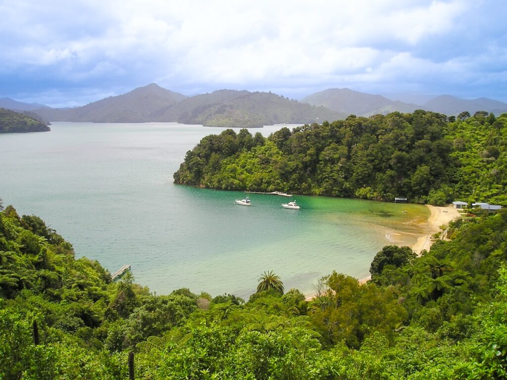
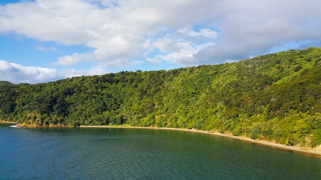
Picton feels busy and practical, but as you turn out of the harbour and slide deeper into Queen Charlotte Sound the hills quickly close in and the water settles into that deep Sounds green. Ferries and local boats bustle in the entrance, then the noise drops away and you’re left with bush, birds and the low thrum of the engine or the rustle of sails. Queen Charlotte Sound is about 45km long by 1km wide providing a significant expanse of water and shoreline to explore Endeavour Inlet has a softer, more relaxed feel. Furneaux Lodge and Punga Cove sit tucked into the head of the inlet, with lawns rolling down to the foreshore and jetties stretching into the bay. The surrounding hills rise steeply, cloaked in native forest, and the inlet itself feels wide and calm, ideal for a first night’s swing on a mooring. On one visit, I watched a pair of kayakers spend half an hour just drifting, cameras down, listening to the evening birdsong.
Attractions
From Endeavour Inlet you can sample one of the most accessible sections of the Queen Charlotte Track. Short walks from Furneaux Lodge or Punga Cove give you elevated views back over the inlet and down Queen Charlotte Sound, with native bush, birds and the odd inquisitive weka along the way. Both lodges offer relaxed eating and drinking, so you can combine a leg stretch with a late lunch or dinner ashore. Furneaux’s large lawns are ideal for kids to burn off energy, while Punga Cove’s hillside layout gives more of a tucked-away feel with steps and paths between chalets and the waterfront bar. Kayak hire is often available, and it’s a great bay to practise paddle techniques in flat water. If the weather is mild, an evening swim off the jetty is a fine way to declare the voyage officially underway
Cautions
Watch lodge water taxi movements, ferries in main sound, and adhere to local speed and wake limits
Facilities
Water and power at lodges for guests; bar, restaurant, limited supplies; no fuel or full groceries
Day 2 – Endeavour Inlet to Ship Cove / Meretoto
11 nautical miles
2hrs sailing time
LUNCH STOP:none planned
MOORING:Anchoring in the bay plus visiting vessel swing room; no marina berths; confirm DOC guidance
Description
Today is an intentional short hop from Endeavour Inlet to Ship Cove, between night berths, facilitating another day in Queen Charlotte Sound, giving time to explore any number of the attractions in this area. You keep mostly within sight of the same enclosing hills, yet the atmosphere shifts subtly as you near the outer reaches of Queen Charlotte Sound. The water often feels a shade bluer, the breeze a touch fresher, and you’re closer to the main routes for tour boats and ferries. Captain James Cook sailed into Meretoto/Ship Cove on January 15, 1770, during his first voyage on the HMS Endeavour. Ship Cove itself is surprisingly intimate for such a historic site. The bay curves gently around a pebbly beach, backed by dense coastal forest that climbs steep slopes behind the Cook memorial and picnic area. A jetty stretches into clear water where visiting yachts, cruise launches and water taxis come and go. On a quiet day it’s easy to imagine a square-rigged ship at anchor, boats shuttling ashore with barrels for water and firewood. It’s a special place to simply sit in the cockpit and look around.
Attractions
A well-maintained track leads from the foreshore to the Ship Cove waterfall, a short, steepish walk through shady bush that rewards you with a small cascade and a sense of being far from the busy ferry routes. Ship Cove is also the official start (or finish) of the Queen Charlotte Track. Even if you don’t plan a major hike, you can walk a short section for elevated views over the cove and out towards Motuara Island and the outer sound. Information panels around the memorial tell the story of Cook’s repeated visits and the early contact between European crews and local Māori. There are toilets, a shelter and picnic tables, so this day can be as active or as relaxed as you wish. Kids tend to enjoy racing between the beach, the monument and the start of the track. Here you really want to refer to the earlier section ‘Special Gems’
Cautions
Tour boats and occasional swell; keep clear of ferry routes and respect DOC reserve boundaries
Facilities
DOC toilets, shelter, picnic tables, drinking water; no fuel, power, groceries or restaurant ashore.
Day 3 – Ship Cove to Tennyson Inlet
36 nautical miles
6hrs 30min sailing time
LUNCH STOP:Waihinau Bay, Bulwar, about 4Nm into Pelorus Sound
MOORING:Club and private moorings plus anchoring in suitable depths; check latest local cruising guides.
Description
Today we link across Queen Charlotte Sound and Pelorus Sound before you turn into Tennyson Inlet. This is not to be rushed, sit back and enjoy the sail through this magnificent scenic part of the Sounds as areas unfold with each new bay. The first stretch heads out Queen Charlotte, with high hills and long, straight reaches giving a sense of scale. As you round into Pelorus Sound, the landscape feels a little wilder and less developed, with fewer lodges and more forested slopes running down to the water. Before entering you’ll notice Rangitoto ki te Tonga / D’Urville Island to the west, which was first sighted by Abel Janszoon Tasman, in 1642, almost 70 years before Captain James Cook arrived. Pelorus Sound is about 55km long and in the order of 15km wide providing an even greater expanse of water and shoreline of 380km to explore. Tennyson Inlet itself narrows again into a classic Sounds cul-de-sac: steep bush, small holiday settlements and quiet bays like Duncan and Penzance tucked under the hillsides. There’s moorings and a small cluster of baches, with the forest dropping almost to the foreshore. Arriving late afternoon, the inlet usually feels calm and enclosed, particularly after the more open crossing between the main sounds.
Attractions
Tennyson Inlet is about simple pleasures. There are short walking tracks linking some of the bays, and the native bush and birdlife are real drawcards for those happy with quiet exploration rather than café-hopping. Fishing, paddleboarding and kayaking all work well here, with the small scale of the bays making it easy to stay close to the yacht. There’s also the psychological benefit of knowing you’ve ticked off the longest leg of the journey, so the crew can properly relax. Some skippers treat this as a “skills day” for crew: man-overboard drills under motor in open water earlier, then gentle close-quarters practice picking up moorings or running the dinghy ashore once you’re settled. If legs are stiff after the long sail, even a short stroll along the road or foreshore at Penzance helps restore circulation and keeps everyone happy for the shorter legs ahead.
Cautions
Watch for shallows, private moorings and boat ramps; allow extra time if headwinds in Pelorus.
Facilities
Very limited facilities; small settlements, no fuel or full groceries; plan from Picton and Havelock.
Day 4 – Tennyson Inlet to Nydia Bay
21 nautical miles
4hrs 30min sailing time
LUNCH STOP:none planned
MOORING:Guest moorings at On The Track Lodge by arrangement; anchoring with care in deeper central water.
Description
Leaving Tennyson Inlet, you retrace your path briefly into the wider Pelorus system before turning towards Nydia Bay, another long, branching inlet with a peaceful, remote feel. The surrounding hills are heavily forested, and as you close the bay the shoreline flattens slightly, with pockets of pasture and lodge buildings appearing among the trees. ( Nydia Bay is known for its shallows and for being very quiet. Much of the western end dries at low water, which forces you to think carefully about where you anchor or pick up a mooring. The upside is a strong sense of seclusion: once you’re settled, it can feel like there’s nobody else around apart from the occasional trampers on the Nydia Track and lodge staff ashore. The water often lies still in the evening, and the surrounding bush gives good shelter from wind in many directions, though you never ignore the tide range.
Attractions
Nydia Bay connects directly with the Nydia Track, a two-day tramping route between Kaiuma Bay and Duncan Bay. Even if you only sample a short section from the Nydia end, you’ll get classic Sounds scenery: regenerating native bush, small streams and regular glimpses back over the water to your anchored boat. Nydia Lodge (DOC) and On The Track Lodge offer different styles of stay ashore, from simple group bunkhouse to more comfortable cabins with meals available. Both provide a change of scene from the boat if the crew feels like a night on land. Lodge-supplied kayaks or paddleboards are often available, and wildlife watching – from stingrays in the shallows to birdlife in the bush – rewards slow, quiet exploration. I still remember realising I was late back for dinner because I’d spent too long watching a ray cruise the sandbanks under the dinghy.
Cautions
Extensive shallows and drying flats; up to ~4 m tidal range; proceed slowly and eye sounder constantly.
Facilities
Lodge power, water, meals and basic services; no marina, fuel or general store – confirm ahead.
Today links Pelorus and Kenepuru Sounds, with the option to pause around St Omer Bay before continuing to Portage. The run out of Nydia Bay rewards an early departure: morning light on the surrounding hills can be spectacular, especially after a still night. Once clear of the bay, you thread back into Pelorus then work your way along towards Kenepuru’s entrance, where the water narrows again. St Omer Bay has a classic holiday-settlement feel, with bach roofs peeking through trees and a beach that invites a lunchtime stop. Depths need watching near the wharf and reef, but in settled conditions it’s a welcoming spot. Portage, by contrast, feels like a small resort outpost. The hotel and its moorings sit on the Kenepuru side of a low saddle, with the Queen Charlotte Track running along the ridge above. Late afternoon light here can be lovely, with hillsides catching the sun on both sides of the narrow peninsula.
Attractions
Try golf at St Omer, or lean into Portage’s easy mix of adventure and comfort. Most crews start by climbing from the resort to the Queen Charlotte Track saddle, where even a short wander delivers those classic double-sound views—Kenepuru on one side, Queen Charlotte on the other. You can keep it simple or arrange a water taxi to turn the ridge section into a longer one-way hike, with native forest, glimpses of boats far below and the kind of stillness that makes you pause more often than planned. Down at sea level, Kenepuru Sound feels quieter than its bigger neighbour. Its sheltered inlets suit kayaks, paddleboards and dinghies, with shags, dolphins and soft afternoon breezes adding to the sense of calm. The winding shoreline gives you plenty to explore before you ease ashore for a relaxed lunch at the resort or one of the small nearby cafés.
Cautions
Mind reef and shoals at St Omer; obey 5-knot zones near jetties and swimmers.
Facilities
Resort offers restaurant, bar, pool, guest services; limited shop; no fuel dock – plan from Picton/Havelock.
Day 6 – Extra Time Around Portage / Kenepuru
0-3 nautical miles
0-1hrs sailing time
LUNCH STOP:none planned
MOORING:Remain on Portage mooring or relocate to suitable anchorage near St Omer/Nopera; reconfirm any resort charges.
Description
This day is your pressure valve in the schedule. You can stay put on a Portage mooring and simply enjoy the resort and nearby walks, or use the yacht to potter further along Kenepuru Sound, picking a quiet bay for lunch and a swim. Kenepuru feels gentler than the bigger sounds, with fewer large vessels and a string of settlements strung along the shoreline. If golf on the wish-list, you might shift to anchor off St Omer/Nopera. Otherwise, keeping the boat based at Portage and heading out in the dinghy or on foot works well. One crew I sailed with ended up declaring this their favourite day of the whole voyage – not because we covered many miles, but because nobody felt rushed and everyone could pick their own level of activity, from poolside nap to ridge-top hike.
Attractions
If you want time on the water without doing the work, boat tours and water taxis are easy to arrange from Portage, whether for sightseeing or quick hops around nearby bays. Fishing charters offer a chance at snapper or blue cod, and on calm days the sheltered coves suit snorkelling, with colourful weed beds and small fish rewarding slow exploration. Photographers enjoy the mix of ridge-top views and shifting light in the inlets, which can change the look of the bay in minutes. Back at the resort, the pool, bar and restaurant add a welcome touch of comfort, turning the stop into a mini-holiday within the voyage. Crews often appreciate the break from cooking, and the chance to unwind properly after a few active days. It’s also a natural point to check provisions, fuel and water before the final run to Havelock. Many people simply settle into the stillness and watch the hills trade colours at dusk—Portage has a knack for slowing the pace without ever feeling dull.
Cautions
as day 5
Facilities
as day 5
Day 7 – Portage to Havelock
14 nautical miles
3hrs sailing time
LUNCH STOP:none planned
MOORING:Visitor berths at Havelock Marina; casual rates from about NZD $45/day for 12 m – confirm current.
Description
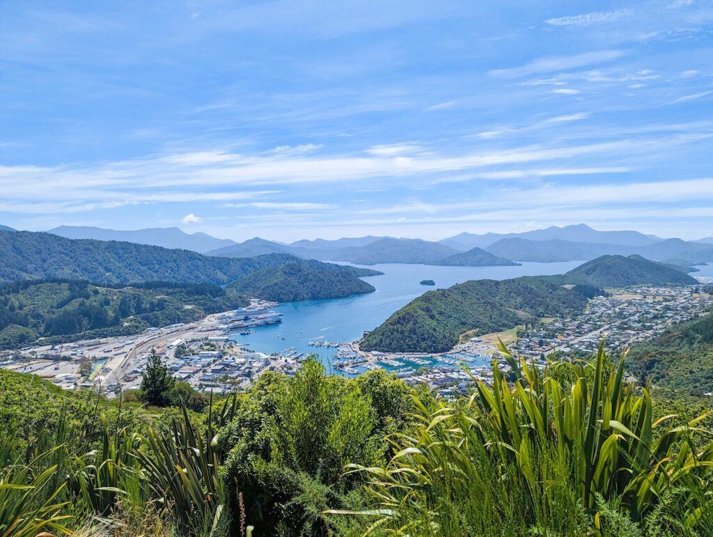
The closing leg from Portage to Havelock feels like a gentle unwinding. You slip away from Kenepuru, re-enter the wider Pelorus system and then work up towards the head of the sound. The hills open out a little, with more visible farmland and scattered houses as you near Havelock. Water traffic picks up again, with local launches, the Pelorus mail boat and fishing boats sharing the channels. Havelock itself is a proper small town clustered around the marina and wharf. The marina basins are packed with local boats, and the backdrop of steep hills reminds you how quickly the land rises from the water. Once alongside, you swap the green hush of the inlets for the clink of rigging, the smell of coffee and the very real temptation of fresh greenshell mussels. It’s a satisfying place to finish a Marlborough Sounds New Zealand sailing voyage: practical, friendly and with plenty of small rewards for the crew.
Attractions
Havelock bills itself as the “greenshell mussel capital of the world”, and sampling local mussels is almost mandatory – whether at a waterside café or cooked aboard. The town also serves as a hub for Pelorus Sound mail-boat trips if you want to extend your time in the region. Ashore, short walks at Cullen Point and Mahakipawa Hill give coastal views back over the sounds and out towards the wider bay – a nice way to reflect on the route you’ve just sailed. Practicalities are good here: you can refuel, top up water, sort laundry and restock groceries before onward travel. If you have time, a quiet wander up the main street reveals the town’s history in information panels and older buildings, including links to Ernest Rutherford and William Pickering.
Cautions
Shallows and marked channels near Havelock; follow leads carefully, allow for tidal streams and cross-winds.
Facilities
Full-service marina with water, power, fuel, café, laundry; short walk to shops, restaurants, medical services.
Facilities Summary
Stop
Water
Fuel
Power
Groceries
Restaurants
Medical/Pharmacy
Picton
✅
✅
✅
Large
Many
Full services in town
Endeavour Inlet
Limited (lodge guests)
⚪
Limited (lodge)
Very small
Lodge restaurants/bars
⚪ (none local)
Ship Cove
✅ (DOC supply)
⚪
⚪
⚪
⚪
⚪
Tennyson Inlet (Penzance)
Limited
⚪
Limited (private)
⚪
Very few/seasonal
⚪
Nydia Bay
Limited (lodges)
⚪
Limited (generators)
⚪
Lodge meals
⚪
Portage
Limited (resort)
⚪
Limited (resort)
Small
Resort restaurant/bar
⚪
Havelock
✅
✅
✅
Medium
Several
Medical centre, pharmacy nearby
Consider the Reverse Route
Running this itinerary from Picton to Havelock lines up nicely with typical summer patterns. Many days see light morning airs building into afternoon sea breezes, often from the north-west or on-shore directions in the main sounds. That makes the longer open-water stretch between Queen Charlotte and Pelorus, on Day 3 in this plan, more comfortable if you can time it for settled conditions and aim to avoid strong southerly changes sweeping in from Cook Strait. Reversing the route – starting in Havelock and finishing in Picton – is certainly possible, but slightly changes the character of the trip. You’d tackle the Pelorus–Queen Charlotte linking leg earlier, with a fresh crew but less feel for the local patterns. You’d also be sailing “into” the busier ferry environment near Picton at the end, when people are often mentally shifting to travel-day mode. In shoulder seasons, when southerly systems and shorter days become more of a factor, finishing in sheltered Kenepuru and Pelorus might be attractive. In peak summer, though, the Picton-to-Havelock flow feels intuitive: start where the ferries arrive, finish with mussels and a quieter marina town.
Support Aids
Whether chartering or welcoming friends onboard your own yacht, these FREE KiwiSailor aids will come in handy and help ease your preparations ….meaning the first drink on this journey is so much more enjoyable:
There are so many variables to consider when planning an itinerary and estimating sailing times and distances, so one needs to appreciate that these are an estimate only.
Read MoreLess
Planned Stopping Locations
As they say, you always plan to ‘sail toward’ and not ‘sail to’, as something unplanned could happen. So one should also consider a ‘bolt-hole’ (a sheltered location where a you can find refuge from bad weather for example). I have not planned for these as there are naturally many variables and options to allow for. So look ahead in the plan and always keep an eye on the weather.
Sailing Distance
I use a planning method that adds a safety margin and thus produces a distance, which tends to be 10–20% longer than charted straight-line or optimised-tool calculations. Assuming:
clearing headlands
tacking angles in light wind
staying outside rocky headlands/fringes
not hugging the coastline
Sailing Time
Sailing time is obviously a function of distance and speed, and again speed can vary considerably. My approach here assumes:
round to the nearest 30 mins
relatively clean hull
a cruising speed of 6 knots, which provides small allowances for:
leaving and entering harbours (but ignore berthing or for example anchoring drop/retrieval time)
trimming sails
occasional lulls
motor sailing if wind is too light to maintain 6 knots
Ultimately my approach is to allow for “steady” sailing as you would normally on vacation, rather than sporty Saturday racing at the local club.
To provide the best experiences, we use technologies like cookies to store and/or access device information. By clicking Accept you are consenting to these technologies and this will allow us to process data such as browsing behaviour or unique IDs on this site. By clicking the close button ‘X’ you will not be consenting, which may adversely affect certain features and functions.
Functional
Always active
The technical storage or access is strictly necessary for the legitimate purpose of enabling the use of a specific service explicitly requested by the subscriber or user, or for the sole purpose of carrying out the transmission of a communication over an electronic communications network.
Preferences
The technical storage or access is necessary for the legitimate purpose of storing preferences that are not requested by the subscriber or user.
Statistics
The technical storage or access that is used exclusively for statistical purposes.The technical storage or access that is used exclusively for anonymous statistical purposes. Without a subpoena, voluntary compliance on the part of your Internet Service Provider, or additional records from a third party, information stored or retrieved for this purpose alone cannot usually be used to identify you.
Marketing
The technical storage or access is required to create user profiles to send advertising, or to track the user on a website or across several websites for similar marketing purposes.