This 7-day Bay of Islands Sailing itinerary from Opua weaves together classic anchorages, short scenic hops, and two slightly longer coastal passages. You’ll swim in sheltered lagoons, walk to island lookouts, explore an old whaling station, and nose into deep, fjord-like Whangaroa before looping gently back via Urupukapuka, Russell and home to Opua.
A relaxed 7-day Bay of Islands Sailing loop from Opua, mixing easy island hops with two coastal adventure legs north to Whangaroa Harbour.
Overview
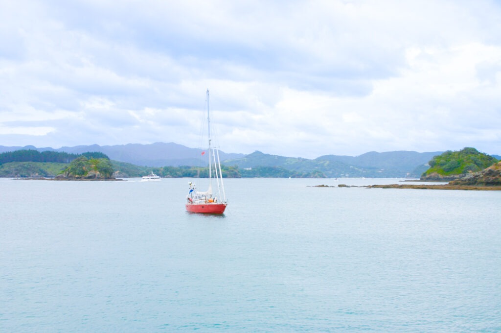
The Bay of Islands is a compact sailing playground: more than a hundred islands, sheltered water, and a mild, maritime climate that lets you get out on the water for much of the year. From a sailor’s point of view, it’s a kind place to learn the ropes, with mostly line-of-sight navigation between bays and plenty of options to duck into shelter if the breeze pipes up. The beauty here is variety. In one week you can go from the busy marina at Opua to quiet lagoons on Motuarohia, from the dramatic cliffs of Cape Brett country down into the snug bowl of Whangamumu, then out along the coast to the Cavalli Islands and the steep green walls of Whangaroa Harbour. This Bay of Islands Sailing route is a circular loop, so logistics are simple: pick up your boat in Opua, sail north and south in a lazy arc, and hand it back in the same place. Distances are modest, the scenery is generous, and there’s just enough navigation interest to keep more experienced skippers smiling without scaring the newcomers. Make sure you’re well stocked before departing Opua as the first 3 nights you’ll be self-sufficient
Special Gems
There are so many fantastic things to do on this Bay of Islands Sailing itinerary that you’ll probably want to book at least another week, or certainly come back for a second or even third visit. There are short scenic extras within the Bay itself, like a slow pass through the channels around Moturua and Waewaetorea, or a lunch stop in a nearby cove en route to Russell, can add variety without changing your overnight stops. These are “micro-gems” – easy additions that stick to the planned itinerary while unlocking some of the Bay’s best water colours and beaches.
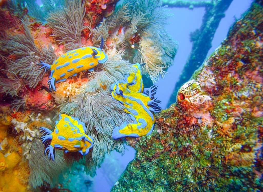
Deep Water Cove – southwest of Cape Brett. Deep Water Cover is a sheltered bright-water bay with superb swimming and a small sandy beach. The wreck Canterbury lies between here and Putahataha Island in 15.7M of water. Or if you’re feeling energetic there is a 16km hiking trail maintained by the Department of Conservation, which provides some spectacular scenery and views.
Mahinepua Peninsula (between Cavalli & Whangaroa – you literally sail past this dramatic coastline on Day 3 and Day 5. The reef fingers and tiny coves along this peninsula offer spectacular close-coast scenery. While not an anchorage to overnight, it’s a superb slow-cruise area in settled weather for photography and spotting rays in the shallows.
Pekapeka Bay (Whangaroa Harbour) – this quiet side-arm sits away from the marina bustle, offering a glassy, protected alternative overnight spot with stunning rock formations and gives a serene “fjord morning light” experience.
Waewaetorea Passage (between Moturua & Waewaetorea — optional micro-detour on Days 1 or 6) – this narrow, bright-water passage lies right beside your route, it’s a favourite among local sailors for quick swims in crystal-clear sand patches. Great for a slow pass-through when the tide is slack.
Birds and Evening Wildlife – around Urupukapuka and some of the pest-controlled islands, birdlife has been recovering; evening walks can reward you with rich birdsong, and on still nights you may even hear kiwi calls from ashore. Keeping night-time noise and lights modest is a small way to support those conservation efforts.
Tall Ships Regatta (Russell, early January) – a colourful, long-running Bay tradition — if your trip overlaps, you’ll share anchorages with classic vessels and enjoy the energy without any need to change your itinerary.
Passage Conditions & Navigation Profile
Typically prevailing north-west to west winds and tides ≈ 2.1–2.6 m
Read MoreLess
Weather, sea, wind considerations — The Bay of Islands typically sees prevailing north-west to west winds, especially in spring and winter; exposed coastlines can be breezy or gusty at 15-25 knots with short, choppy seas. In summer, lighter sea breezes and calm patches often ease conditions, making anchorages inside the islands particularly pleasant.
Level of navigation required — Most passages inside the Bay are suitable for line-of-sight navigation. Only the coastal legs (e.g. rounding headlands or Cape Brett approach) demand a prepared navigation plan using charts, tide and swell forecasts, especially if weather is fresh or swell sets.
Tides and currents — Tides in the Bay follow a semi-diurnal cycle (two highs, two lows roughly every 24 h). High-tide range is typically ≈ 2.1–2.6 m, low tide around 0.6 m, yielding moderate changes in depth and shoreline exposure. There are no widely charted strong “tidal-gates” or narrow tidal-races typical of major estuaries — currents remain moderate in normal conditions, but careful attention is needed near narrow heads and reef-fringed entrances at changing tides.
Day 1 – Opua to Motuarohia (Roberton Island)
I find this is the perfect start from busy, easy-access Opua, as you re well stocked and there’s no rush or stress in this short gentle sail. Head out past the tourist boats into the central Bay and as you weave between the inner islands you’ll feel the land fall away behind and the water open up. Motuarohia (Roberton Island) lies low and green ahead, with its curving twin lagoons tucked into the southern shore and steeper cliffs to the north. It’s a classic first-day hop: just far enough to feel like you’ve gone somewhere, not so far that anyone has time to get nervous.
10 nautical miles
2hrs sailing time
LUNCH STOP:none planned
MOORING:Anchor in sand off the main southern beach; no fee, arrive early in peak season for space.
Description
I find this is the perfect start from busy, easy-access Opua, as you re well stocked and there’s no rush or stress in this short gentle sail. Head out past the tourist boats into the central Bay and as you weave between the inner islands you’ll feel the land fall away behind and the water open up. Motuarohia (Roberton Island) lies low and green ahead, with its curving twin lagoons tucked into the southern shore and steeper cliffs to the north. It’s a classic first-day hop: just far enough to feel like you’ve gone somewhere, not so far that anyone has time to get nervous.
Attractions
Drop the hook in settled weather off the southern beach, then head ashore. A short track climbs up through scrub to the central lookout, giving a textbook Bay of Islands panorama and a great first photo of the trip. Snorkel the rocky headlands, kayak around the lagoons, or simply float off the beach. In the evening, watch tour boats disappear back towards Paihia while you stay on in the quiet, with just a few anchor lights and the odd splash of fish breaking the surface.
Cautions
Open to strong easterlies and wakes from passing boats; maintain distance from reefy heads and give room for swinging.
Facilities
No shore facilities; bring all water, food and fuel from Paihia or Opua beforehand.
Day 2 – Motuarohia (Roberton Island) to Whangamumu Harbour
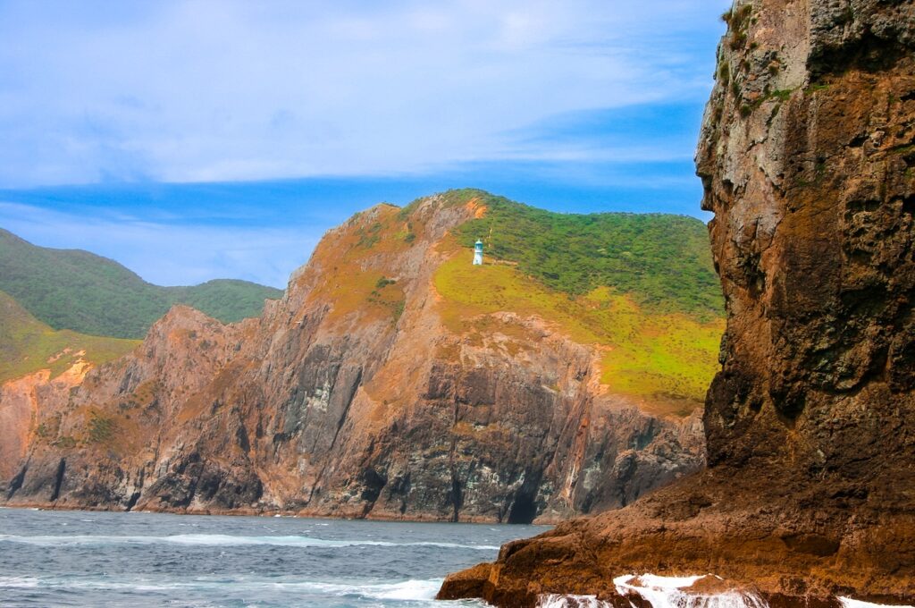
Leave the heart of the Bay and shape a course towards Cape Brett, watching the islands slide astern and the coast grow more rugged. Once you round the cape in suitable weather, you’re briefly on open coastline with swell and more ocean feel under the keel. Whangamumu Harbour opens as a sheltered bite in the cliffs, well protected in most conditions and ringed with bush-covered hills. You’ll feel like you’ve slipped into a secret basin, well away from the busier Bay of Islands Sailing traffic.
16 nautical miles
3hrs 30mins sailing time
LUNCH STOP:none planned
MOORING:Free anchoring in sand/mud patches with good holding; no marina or buoys, just choose a suitable swinging circle.
Description
Leave the heart of the Bay and shape a course towards Cape Brett, watching the islands slide astern and the coast grow more rugged. Once you round the cape in suitable weather, you’re briefly on open coastline with swell and more ocean feel under the keel. Whangamumu Harbour opens as a sheltered bite in the cliffs, well protected in most conditions and ringed with bush-covered hills. You’ll feel like you’ve slipped into a secret basin, well away from the busier Bay of Islands Sailing traffic
Attractions
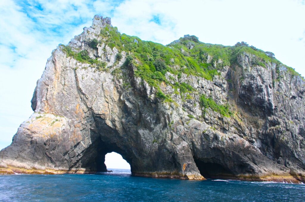
You will pass the famous Hole in the Rock, just off Cape Brett, giving an ideal opportunity to snap a couple of pics of this marvel. Anchor and take the dinghy ashore to explore the historic whaling station remains on the western side of the harbour, now softened by bush and birdsong.(Doc.govt.nz) There are walking tracks into the surrounding hills, good for stretching legs after the longer sail. In settled weather, some skippers like to poke back out for an evening fish along the headlands; others are happy to linger onboard, watching the light change on the tree-covered slopes. This is a good night for stargazing too, with minimal town glow.
Cautions
Watch swell and forecast before committing; entrance can be uncomfortable in strong easterlies. Mind rocks near the harbour mouth and stay within charted leads.
Facilities
No water, fuel, power or shops; self-sufficient anchorage with only walking tracks and the old station ashore.
Day 3 – Whangamumu Harbour to Cavalli Islands
This is your big coastal day. Slip out of Whangamumu in good light, round Cape Brett again with plenty of offing, then head north along a coast of headlands and sandy bays. Swell and breeze feel more “Pacific” here, but the route is straightforward in settled weather. If you have divers on board then priority will be to hit Cavalli Islands sooner rather than later to ensure time of one or two dives. Otherwise you could opt to break the trip with a mid-day stop in a suitable bay for lunch and a swim before pressing on to the Cavalli group, low islands scattered off the mainland with inviting sandy coves and clear water.(
28 nautical miles
5hrs 30mins sailing time
LUNCH STOP:none planned
MOORING:Anchoring in sand patches in chosen bay; no formal moorings, no fees, first-come first-served.
Description
This is your big coastal day. Slip out of Whangamumu in good light, round Cape Brett again with plenty of offing, then head north along a coast of headlands and sandy bays. Swell and breeze feel more “Pacific” here, but the route is straightforward in settled weather. If you have divers on board then priority will be to hit Cavalli Islands sooner rather than later to ensure time of one or two dives. Otherwise you could opt to break the trip with a mid-day stop in a suitable bay for lunch and a swim before pressing on to the Cavalli group, low islands scattered off the mainland with inviting sandy coves and clear water
Attractions
Choose a sheltered bay in the Cavallis, such as Waiiti Bay on Motukawanui, for the night.. Rainbow Warrior Dive & Snorkel – certified divers can join local operators to explore the coral and fish life that now cloak the hull, turning a piece of history into a living reef. Non-divers don’t miss out: the surrounding reefs and shallows offer excellent snorkelling in clear water, so you can still enjoy the marine life without going deep. As the sun drops, the islands silhouette against the horizon and it feels a long way from the bustle of Opua – in the best possible way.
Cautions
Exposed to swell and wind shifts; study charts carefully for reefs and isolated rocks, and avoid night entries or exits.
Facilities
No services on the islands; nearest fuel, water and shops back on the mainland (e.g. Matauri Bay or Whangaroa by road.
Day 4 – Cavalli Islands to Whangaroa Harbour
A shorter hop today, with time to enjoy a relaxed morning swim before weighing anchor. Sail north-west along the coast, then turn into the well-marked entrance to Whangaroa Harbour. Cliffs and crags close in as you proceed, giving the feeling of entering a sheltered fjord. The inner harbour offers several inlets and anchorages, plus the small settlement and marina tucked under steep hillsides. The sense of enclosure and still water after days of open coastline is quite striking.
15 nautical miles
3hrs sailing time
LUNCH STOP:none planned
MOORING:Berths at Whangaroa Marina (booking recommended in busy times) or anchoring in designated bays; standard marina charges apply.(
Description
A shorter hop today, with time to enjoy a relaxed morning swim before weighing anchor. Sail north-west along the coast, then turn into the well-marked entrance to Whangaroa Harbour. Cliffs and crags close in as you proceed, giving the feeling of entering a sheltered fjord. The inner harbour offers several inlets and anchorages, plus the small settlement and marina tucked under steep hillsides. The sense of enclosure and still water after days of open coastline is quite striking
Attractions
Take a berth or secure anchorage, then head ashore. Walk one of the local tracks to viewpoints above the harbour, or just wander the small settlement and enjoy a bite at the local pub or café. The rock formations and bush make this a favourite for photographers. If you’re keen on fishing, the harbour and nearby coast are well regarded. One season I misjudged the tide here and ended up doing a slightly embarrassing shuffle off a drying patch – a gentle reminder that even in such a calm harbour, the basics still matter.
Cautions
Harbour is deep in places; check depth carefully when anchoring. Watch for local traffic and maintain low wake near jetties and moored boats.
Facilities
Water, fuel and power from marina; small store, café and pub onshore; basic medical supplies only.
Day 5 – Whangaroa Harbour to Urupukapuka Island (Paradise Bay)
Retrace your path out of Whangaroa and head south along the coast, choosing a pleasant bay such as Matauri Bay or Tauranga Bay for a mid-day break. After lunch, continue towards Cape Brett, then angle back into the Bay of Islands proper. Urupukapuka Island rises ahead with its rolling grassy hills, bush gullies, and several well-sheltered bays. Paradise Bay on the eastern side feels wonderfully tucked away despite being so close to the main Bay cruising grounds.
32 nautical miles
6hrs sailing time
LUNCH STOP:Matauri Bay or Tauranga Bay
MOORING:Anchoring in sand with decent shelter; some areas may have public moorings – check latest local information and any DOC guidance.
Description
Retrace your path out of Whangaroa and head south along the coast, choosing a pleasant bay such as Matauri Bay or Tauranga Bay for a mid-day break. After lunch, continue towards Cape Brett, then angle back into the Bay of Islands proper. Urupukapuka Island rises ahead with its rolling grassy hills, bush gullies, and several well-sheltered bays. Paradise Bay on the eastern side feels wonderfully tucked away despite being so close to the main Bay cruising grounds.
Attractions
Drop anchor for lunch and a swim at somewhere like Matauri Bay or just further south around Motuiwi Island. Then head back south and anchor in Paradise Bay and enjoy one of the best all-round island stops in the Bay of Islands Sailing area. Swim from the sandy beach, explore the shoreline by dinghy, or follow walking tracks over the island for wide views back towards Cape Brett and into the Bay. Birdlife is often active, especially in the evening. If you’re happy to stretch your legs, you can wander across to the island’s campground area or nearby bays. This is a restful, “just enjoy being here” kind of stop.
Cautions
Can be busy in peak season; avoid anchoring too close to the beach or other boats, and monitor wind shifts overnight.
Facilities
No regular fuel or power; seasonal basic facilities at campground, but treat this as a self-sufficient anchorage for water and groceries.
Day 6 – Urupukapuka Island (Paradise Bay) to Russell
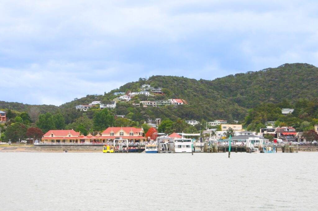
A leisurely sail back into the heart of the Bay. Depart Paradise Bay, weave between nearby islands, and point the bow towards historic Russell. As you close in, you’ll see the waterfront strip of buildings, the old church, and the sheltered bay filled with moorings, visiting yachts, and ferries shuttling across to Paihia. Russell feels like a small village that remembers its wild past but has mostly settled into a gentler rhythm.
6 nautical miles
1hrs 30 min sailing time
LUNCH STOP:none planned
MOORING:Mooring buoys and marina/wharf berths available; fees apply and booking is wise in high season, especially for larger vessels.
Description
A leisurely sail back into the heart of the Bay. Depart Paradise Bay, weave between nearby islands, and point the bow towards historic Russell. As you close in, you’ll see the waterfront strip of buildings, the old church, and the sheltered bay filled with moorings, visiting yachts, and ferries shuttling across to Opua. Russell feels like a small village that remembers its wild past but has mostly settled into a gentler rhythm.
Attractions
Pick up a mooring or berth and head ashore by dinghy. Russell offers cafés, restaurants, an historic pub, and the famous waterfront for a stroll. Visit the old church and museum, wander the back streets, or take a short hill walk for panoramic views over the Bay of Islands Sailing grounds you’ve just travelled. Evening here is about good food, a glass of something nice, and perhaps swapping sea stories with other crews.
Cautions
Busy ferry traffic and water taxis; keep clear of channels and observe speed restrictions. Check depth carefully near the shore.
Facilities
Water, fuel, power, groceries, cafés, restaurants and medical/pharmacy services available in Russell township.
Day 7 – Russell to Opua
For your final day, enjoy a short sail across the inner Bay back towards Opua. You have plenty of time on your hands and will doubtless pause in a nearby bay such as Matauwhi or Tapeka for a last swim and lunch. The water is usually calm, and the route is busy with ferries, dolphins on a good day, and other yachts coming and going. As Paihia’s wharf and waterfront come back into view, you complete the circular Bay of Islands Sailing loop, feeling that the coastline now looks much more familiar.
7 nautical miles
1hr 30mins sailing time
LUNCH STOP:none planned
MOORING:Return to your charter berth or pre-arranged mooring at Opua; standard berth or mooring fees apply with prior booking.
Description
For your final day, enjoy a short sail across the inner Bay back towards Opua. You have plenty of time on your hands and will doubtless pause in a nearby bay such as Matauwhi or Tapeka for a last swim and lunch. The water is usually calm, and the route is busy with ferries, dolphins on a good day, and other yachts coming and going. As Opua’s wharf and waterfront come back into view, you complete the circular Bay of Islands Sailing loop, feeling that the coastline now looks much more familiar.
Attractions
Use the morning for any last dips, photos, or dinghy explorations before heading in. Once tied up and checked back in, you might visit the Waitangi Treaty Grounds nearby, browse Paihia’s shops, or simply sit with an ice cream watching boats you now recognise setting off on their own adventures. If you have an extra night ashore, there are plenty of land-based tours to waterfalls, kauri groves, or Kerikeri’s historic Stone Store.
Cautions
Watch ferry routes and swim zones near the beach; keep speed down and maintain a sharp lookout in the busy inner harbour.
Facilities
Full services in Opua and nearby Paihia: fuel, water, shore power, supermarkets, restaurants, cafés, tour offices and medical/pharmacy services.
Facilities Summary
(✅ = generally available / ⚪ = not available or very limited)
Location
Water
Fuel
Power
Groceries
Restaurants/Cafés
Medical/Pharmacy
Opua
✅
✅
✅
✅
✅
✅
Motuarohia (Roberton)
⚪
⚪
⚪
⚪
⚪
⚪
Whangamumu Harbour
⚪
⚪
⚪
⚪
⚪
⚪
Cavalli Islands
⚪
⚪
⚪
⚪
⚪
⚪
Whangaroa Harbour
✅ (limited)
✅
✅
✅ (small)
✅
Limited
Urupukapuka (Paradise Bay)
⚪ (campground only, seasonal)
⚪
⚪
⚪
⚪
⚪
Russell
✅
✅
✅
✅
✅
✅
Consider the Reverse Route
This itinerary run: out from Opua to the islands, down to Whangamumu, up the coast to Cavalli and Whangaroa, then back into the Bay via Urupukapuka and Russell. For most typical summer weather patterns this works well, giving you more downwind or reaching conditions on the longer coastal legs and keeping the open-coast days closer to mid-trip, when the crew is settled in. Running the loop in reverse is certainly possible. You’d head straight to Russell and Urupukapuka first, then north to Whangaroa and the Cavallis before returning via Whangamumu and back around Cape Brett. This could suit if a northerly pattern dominates and you prefer to do the long legs early. The trade-off is starting with your more complex navigation days before everyone has found their sea legs. Either direction still delivers the core Bay of Islands Sailing highlights; choose the version that best matches the season’s wind trends and your crew’s confidence.
Support Aids
Whether chartering or welcoming friends onboard your own yacht, these FREE KiwiSailor aids will come in handy and help ease your preparations ….meaning the first drink on this journey is so much more enjoyable:
There are so many variables to consider when planning an itinerary and estimating sailing times and distances, so one needs to appreciate that these are an estimate only.
Read MoreLess
Planned Stopping Locations
As they say, you always plan to ‘sail toward’ and not ‘sail to’, as something unplanned could happen. So one should also consider a ‘bolt-hole’ (a sheltered location where a you can find refuge from bad weather for example). I have not planned for these as there are naturally many variables and options to allow for. So look ahead in the plan and always keep an eye on the weather.
Sailing Distance
I use a planning method that adds a safety margin and thus produces a distance, which tends to be 10–20% longer than charted straight-line or optimised-tool calculations. Assuming:
clearing headlands
tacking angles in light wind
staying outside rocky headlands/fringes
not hugging the coastline
Sailing Time
Sailing time is obviously a function of distance and speed, and again speed can vary considerably. My approach here assumes:
round to the nearest 30 mins
relatively clean hull
a cruising speed of 6 knots, which provides small allowances for:
leaving and entering harbours (but ignore berthing or for example anchoring drop/retrieval time)
trimming sails
occasional lulls
motor sailing if wind is too light to maintain 6 knots
Ultimately my approach is to allow for “steady” sailing as you would normally on vacation, rather than sporty Saturday racing at the local club.
To provide the best experiences, we use technologies like cookies to store and/or access device information. By clicking Accept you are consenting to these technologies and this will allow us to process data such as browsing behaviour or unique IDs on this site. By clicking the close button ‘X’ you will not be consenting, which may adversely affect certain features and functions.
Functional
Always active
The technical storage or access is strictly necessary for the legitimate purpose of enabling the use of a specific service explicitly requested by the subscriber or user, or for the sole purpose of carrying out the transmission of a communication over an electronic communications network.
Preferences
The technical storage or access is necessary for the legitimate purpose of storing preferences that are not requested by the subscriber or user.
Statistics
The technical storage or access that is used exclusively for statistical purposes.The technical storage or access that is used exclusively for anonymous statistical purposes. Without a subpoena, voluntary compliance on the part of your Internet Service Provider, or additional records from a third party, information stored or retrieved for this purpose alone cannot usually be used to identify you.
Marketing
The technical storage or access is required to create user profiles to send advertising, or to track the user on a website or across several websites for similar marketing purposes.